 |
| Another reminder : America the brave |
We returned to the northern Catskills beginning in West Fulton. West Fulton is little country town with only a single store called the US post office. The area is surrounded by hills, farms and maple trees. Chris and I parked a car on Durfee Rd in Middleburgh and shuttled to West Fulton for a long hike. We planned a weekend of hiking the Long Path and on this first day we were going to walk 17+ miles, over a few peaks, including the areas hiking hotspot, Vromans nose. We set off at a rapid pace and enjoyed the warm spring weather under a clear blue sky. The woods were chirping with birds and the trees were in bud, in stark contrast to our last outing where we fought through deep snow. We found a bleached white deer skull and I tied it on my pack as a cool bone yard piece. We pushed up a summit at a fast a pace as we were into making good time.
After a few hours of pushing miles, often uphill, we
 |
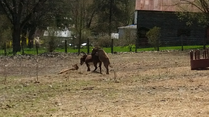
| RANDY the MULE |
exited the woods onto Route 30 and road walked along large farms in what is called Vromansland. As we passed by a petting zoo type farm, a randy mule ran at us braying in a display of male domination before running over to a nearby female to mount her. We laughed at his barnyard hi-jinx. Soon after, we passed the "Octagon house" from 1854. It was interesting and well preserved. A local garage was decorated with scrap metal in the shape of old glory. Farmers were busy tilling soil and preparing for seeding. We approached Vroman's nose and looked up at the cliffs and could see people in bright neon clothing walking along the edge. We started up the trail in almost disbelief at how steep it was.
 |
| Vromansland |
 |
| Chris on top of Vroman's nose |
 |
| Vromansland from above |
The trail was cut into a steep diagonal along a scree pile that you could go sliding down if you slipped . I totally sucked wind on the way up and drank almost half my water to quench my never ending thirst as I toiled up 400 feet in like 1/8 of a mile. We paused at the top to catch some air. The top is a real attraction and makes the strenuous climb well worth every step. The views of the valley spanned all the way to the larger Catskills to the south and were stunning. Many young girls were up there in separate groups, simply enjoying the day and the scenery. I saw the "neon" family in their bright clothes and greeted them with a few brightly colored jokes. They were really nice and mentioned they saw an eagle nesting on the cliffs below. We immediately perked up at this fact and they volunteered to show us the eagle.We walked the edge for a few hundred yards and the bird was there as promised, except it wasn't an Eagle. Chris again perked up and said it was a Peregrine Falcon. It had piecing eyes, gray and white plumage, yellow feet with talons. I took pictures of it on my cell phone and did my best to capture it.
 |
| View of Vromansland from the "nose" |
 |
| Chris and Chembrew |
 |
| PEREGRINE FALCON |
Chris said these birds are the fastest animals known and hunt other birds by picking them off in mid flight. I just confirmed his encyclopedic memory because Wikipedia indicated these birds have been clocked at a whopping 242 mph. We were very pleased at seeing this majestic creature in the wild and thanked the neon family many times over for taking us to see the bird. We next paused for lunch on the actual promontory of Vroman nose. The cliffs here jutting out over the valley below and the views were toward Middleburgh. You could see the outline of the Adirondacks in the distance and the Schoharie creek below. After lunch, we descended to the valley and walked the remaining section into Middleburgh. We refilled water and grabbed a snack at a local store and headed across town to the cliffs. We followed what we thought was a turn blaze and then lost the path in the middle of the city streets. No big deal, we went a few more blocks in the direction on the map and picked it up again after a local pointed us to the trail head going up the cliffs.
 |
| 1854 Octagon house |
The cliffs were again steep and we got to the top between a clef in the rock. There were extension cords and Christmas lights hung all along the top of the cliff suggesting the locals occasionally lit up cliffs with light using generators. We found an ATV parked up top, so we obviously took the harder way up. We continued our fast pace for another mile, but that came crashing down when my legs suddenly cramped up and I had to stop to work out the kinks. The last few miles were uphill so I had to rest more to avoid serious cramping and just worked out the knots in my quads. The earlier fast pace was a mistake that was now slowing us down. We eventually made the car and we celebrated with a cold adult beverage. My GPS indicated we traveled 18.3 miles, in about seven hours, so we really had a good day, even though my legs cramped up a bit. I was actually concerned about whether I could do it again the next day, but we decided to rest and play it by ear. We traveled to my buddies place in East Durham and had a good meal and a few stouts at the Shamrock, while listening to a country and western band. We were both falling asleep in our seats towards the end and decided to call it a night.
 |
| Coco the Miniature horse and Bob P. |
 |
| Tuggs Pond |
 |
| Finally made it to Albany County! |
The next morning was bright and sunny. We checked out my buddies new miniature horse he bought for his petting zoo farm the day before. He named it Coco. We had breakfast at the Middleburgh diner and formed our plan for the hike. We parked a car on rt 6 at Partridge Run rd and went back to Durfee to renew our hike up cotton hill. The shelter there was in really good shape would be a great place to spend a night after a hike.
 |
| Copper the Pet Pig |
 |
| We shared the trail with 4X4's at times.. |
We passed a homestead with a pet pig around 300 pounds. We went through a camp and back down to cotton hill road. Next up a long climb to the top of Cannary Hill. We pushed through forests and ATV trails and ended going downhill though private land with muddy ATV tracks before hitting the road. We road walked a few miles and took a lunch break at the border of Schoharie and Albany Counties. The road and trail here are basically long distance snowmobile trails labelled 7B. We continued road walking and finally went back into the woods. It soon entered a clear cut section and wound around a beaver pond. We enter a cathedral of perfectly plant spruce trees towering 50 feet in an arched canopy overhead. It was a great church for a Sunday hike. We took a short break to stretch tired legs and continued on to the lake section. There are a series of diked lakes with cascading brooks interlinking the lakes. Tuggs pond was scenic and we continued down to Fawn lake. There are docks for swimming and launching a Kayak. We passed a gorge and then down to a fourth and final lake. Another mile walk and we were at the car. Only about 14 miles this day. My GPS indicated we went 32 miles in the two days. I again recorded the tracks and will add some GPS screen shots here along with the actual gps data when I figure it out. We are now firmly in Albany County. Woohoo! We are only about 25 miles from the end in Altamont. Can't wait to find a weekend and complete this one! I imbedded a google eath viewer for this GPS dataset below. Zoom in to the west Fulton area to start. The complete data file is also available here as a download:
West Fulton to Partridge Run GPS data
Trail Stats: Day 1 18.3 miles (per GPS)
Trail Stats Day 2: 14.4 mile (per GPS)
I'm writing this a few days later. Like a small miracle, I had zero aches and pains the next day after the hike or thereafter. Looking back, I never had knee pain during either days hike. If you are reading this and suffer with such things (like I do typically), trust me there is hope! You can work through it. The only thing I take daily now is Glucosamine/Condriotan and MSM in one combined daily tablet (CVS brand). I'm very excited to be here writing this bit because I didn't think it was possible to not have knee pain while hiking. I think I also improved my posture now when hiking by not leaning forward as much.


No comments:
Post a Comment